

Cold Front Brings Rain, Gusty Winds, and Chilly Temperatures to Brunswick County
BRUNSWICK COUNTY, NC — A strong autumn cold front sweeping through coastal North Carolina will bring scattered showers, gusty northerly winds, and a sharp drop in temperatures across Brunswick County today.
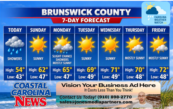
Rain chances will peak this afternoon behind the front as gusty winds build up to 31 mph, sending temperatures falling into the upper 50s by late afternoon. Skies will clear Sunday, making way for a sunny but crisp and breezy start to the workweek.
Current Watches, Warnings & Marine Advisories
-
Wind Advisory / Gusty Winds: Northerly winds will increase significantly this afternoon, blowing 13 to 18 mph with gusts up to 31 mph. Strong gusts around 25 to 29 mph will persist through Sunday and Monday.
-
Marine & Coastal Hazards: Rough ocean conditions, elevated surf, and hazardous boating conditions are expected offshore due to sustained northerly winds exceeding 15–18 mph through early next week.
Brunswick County Detailed Forecast
-
Today: Showers likely, mainly after 11 AM. Mostly cloudy, with a temperature falling to around 56°F by 5 PM. North wind 7 to 12 mph increasing to 13 to 18 mph in the afternoon. Winds could gust as high as 31 mph. Chance of precipitation is 60%. New precipitation amounts of less than a tenth of an inch possible.
-
Tonight: A chance of showers, mainly before 8 PM. Mostly cloudy during the early evening, then gradual clearing, with a low around 46°F. North wind around 18 mph, with gusts as high as 29 mph. Chance of precipitation is 30%. New precipitation amounts of less than a tenth of an inch possible.
-
Sunday: Sunny, with a high near 65°F. North wind around 18 mph, with gusts as high as 28 mph.
-
Sunday Night: Partly cloudy, with a low around 50°F. North wind around 16 mph, with gusts as high as 25 mph.
-
Monday: A slight chance of showers. Mostly sunny, with a high near 68°F. North wind around 17 mph, with gusts as high as 25 mph. Chance of precipitation is 20%.
-
Monday Night: Partly cloudy, with a low around 50°F.
-
Tuesday: Sunny, with a high near 71°F.
-
Tuesday Night: Mostly clear, with a low around 52°F.
-
Wednesday: Sunny, with a high near 72°F.
-
Wednesday Night: Partly cloudy, with a low around 52°F.
-
Thursday: Mostly sunny, with a high near 71°F.
-
Thursday Night: Partly cloudy, with a low around 52°F.
-
Friday: Mostly sunny, with a high near 72°F.
Safety Precautions & Preparedness Guidelines
Roadway Safety
-
Wind Hazards: Drivers of high-profile vehicles, campers, and boat trailers traveling along US-17, NC-211, and the Oak Island/Holden Beach causeways should exercise extra caution due to strong crosswinds gusting up to 31 mph.
-
Slick Conditions: Light afternoon rain will combine with oil residue on roadways, leading to slick conditions. Reduce speeds and increase following distance during the afternoon commute.
Ocean & Beach Safety
-
High Surf & Rip Currents: Strong, sustained northerly winds will produce rough surf and choppy marine conditions along South Brunswick Islands beaches. Swimming is strongly discouraged.
-
Secure Outdoor Items: Residents and coastal property owners should secure loose lawn furniture, trash cans, and outdoor Halloween decorations ahead of gusty winds today and tonight.
© 2026 CoastalCarolinaNews.com | Jones Media Partners LLC
No content from this publication may be reproduced, republished, or used for commercial purposes without prior written authorization from Jones Media Partners LLC. For questions or comments call 910.898.2770 or you can reach out via our Contact Page.

Be the first to comment