
Horry County 7-Day Weather Forecast: Friday November 6, 2026
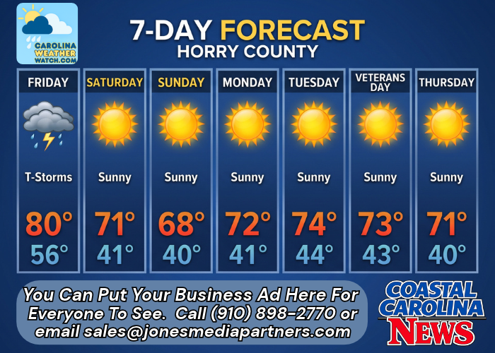
A approaching cold front across Horry County brings a 90% chance of showers and potential afternoon thunderstorms on Friday before skies clear out Friday night, paving the way for a sunny, crisp weekend across the Grand Strand.
Current Watches, Warnings & Marine Advisories
-
Thunderstorm & Rain Risk: High probability of showers and thunderstorms on Friday (90% chance of precipitation), with general rainfall amounts between a tenth and a quarter of an inch, though localized higher amounts are possible during thunderstorms.
-
Winds & Marine Hazards: Southwest winds reaching up to 7 mph on Friday with gusts up to 15 mph. Winds shift to the north on Saturday at 6 to 9 mph, with gusts up to 17 mph along the coast.
Horry County Detailed Forecasts
Horry County 7-Day Detailed Forecast
-
Friday: A chance of showers and thunderstorms, then showers and possibly a thunderstorm after 1pm. High near 80. Calm wind becoming southwest 5 to 7 mph. Winds could gust as high as 15 mph. Chance of precipitation is 90%. New rainfall amounts between a tenth and quarter of an inch, except higher amounts possible in thunderstorms.
-
Friday Night: Showers likely and possibly a thunderstorm before 7pm, then a slight chance of showers between 7pm and 8pm. Cloudy during the early evening, then gradual clearing, with a low around 56. Calm wind becoming north around 5 mph after midnight. Chance of precipitation is 60%. New precipitation amounts of less than a tenth of an inch, except higher amounts possible in thunderstorms.
-
Saturday: Sunny, with a high near 71. North wind 6 to 9 mph, with gusts as high as 17 mph.
-
Saturday Night: Mostly clear, with a low around 41. Light north wind.
-
Sunday: Sunny, with a high near 68.
-
Sunday Night: Mostly clear, with a low around 40.
-
Monday: Sunny, with a high near 72.
-
Monday Night: Clear, with a low around 41.
-
Tuesday: Sunny, with a high near 74.
-
Tuesday Night: Partly cloudy, with a low around 44.
-
Veterans Day: Sunny, with a high near 73.
-
Wednesday Night: Mostly clear, with a low around 43.
-
Thursday: Sunny, with a high near 71.
Safety Precautions & Preparedness Guidelines
Roadway Safety
-
Wet Roadway Hazards: Showers and thunderstorms after 1 p.m. Friday will create slick conditions along major corridors including U.S. 17, U.S. 501, and S.C. 31. Drivers should reduce speeds to prevent hydroplaning.
-
Gusty Winds: Drivers of high-profile vehicles on coastal bridges and overpasses should use caution with wind gusts reaching up to 15–17 mph through Saturday.
Ocean & Beach Safety
-
Surf & Rip Currents: Gusty southwest winds Friday afternoon followed by northerly breezes on Saturday will create rough surf conditions along Grand Strand beaches. Swimmers should exercise caution.
© 2026 CarolinaWeatherWatch.com | Jones Media Partners LLC
No content from this publication may be reproduced, republished, or repurposed without prior written authorization from Jones Media Partners LLC.

Be the first to comment