

")
Welcome to another edition of the Brunswick County Weather Update. Thank you for taking the time to read this. Today’s is rather lengthy.
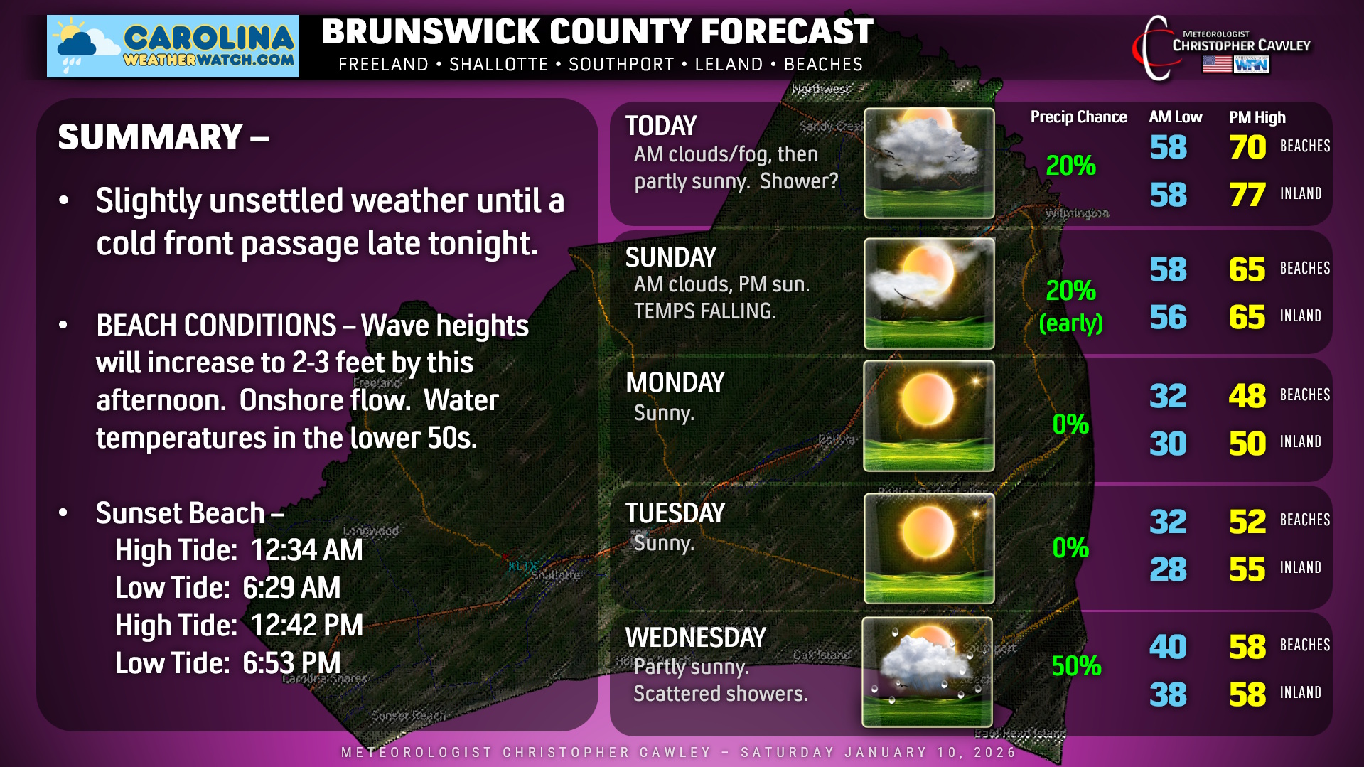
First, let’s talk about today, tonight, and Sunday. An unseasonably warm and somewhat humid air mass is in place. A south-to-north (onshore) flow means we’ll probably see a few spotty rain showers, especially closer to the beaches, less likely farther inland. Temperatures will have a bit of a swing, ranging from the upper 60s to around 70 at the beach… to the upper 70s inland. Given enough sunshine, areas along the Columbus County line may reach the 80-degree mark.
A strong cold front will sweep across the county late tonight. Scattered showers are probable ahead of and along the front, but overall rainfall amounts should be a tenth of an inch or less.
A second front races in behind the first one on Sunday morning. Once the second front clears the coast, our skies will rapidly clear and temps start to fall.
Sunday night through Tuesday: Canadian high pressure will take control and bring … well … seasonable temps to the county for a change. Monday is going to be rather chilly with highs running from the upper 40s at the beaches to around 50 inland. Temps Monday night dip into the 20s inland but stay around the freezing mark at the beaches.
Wednesday: Our next weather system starts to approach, in the form of yet another cold front. This will probably bring scattered showers to the area with temps slightly above seasonal normal values.
Beyond that, unsettled weather is possible toward the end of next week, as the European model wants to develop a low off the Carolina coast going into Friday. There will be some colder air pushing in Thursday into Friday… but I think at this point whatever precipitation activity toward the end of next week will be liquid.
But things could get… interesting…
WILL IT SNOW??? “Hey Chris, this dude on Facebook said it’s gonna snow!”
Ok here’s where we’re at, and this applies to Brunswick, Columbus, and Horry counties. The overall pattern is changing, so let’s talk about expectations.
We haven’t seen patterns favorable for wintry precipitation yet this season, but that is changing as we move through the second half of January.
Don’t get too excited. That does NOT mean “snow” is a certainty, especially here in the coastal Carolinas, but it does mean that overall patterns are more favorable. I know… vague.
First of all, the definition of a “measurable” snowfall is one-tenth of an inch. That’s barely noticeable in the grass. But that counts as measurable snow. Zero impacts.
So what is the longer-range modeling showing? When looking at modeling, I prefer to look at model ENSEMBLES. The “big two,” the GFS and the European, have the single image (the ones people like to post on social media), and then they have a GROUP of models called the “ensemble.” Think of an orchestra, each instrument is part of the ensemble. Anyway, the European has 50 ensemble “members,” plus a “control,” and the GFS has 30. Looking at ENSEMBLE model data, yes there is the chance for measurable snowfall over inland Brunswick County before the end of the month. The latest European ENSEMBLE model consensus has 5 out of 50 members showing “measurable” snowfall within the next 10 days, which is a 10% chance. The GFS ENSEMBLE consensus has 4 out of 30 members with “measurable” snowfall… a 13.3% chance.
“So you’re saying there’s a chance!” Yes, I’m saying there’s a chance. There’s also a chance that everyone reading this blog wins the lottery and becomes a multimillionaire.
Anyway, NONE of this represents a forecast. It IS “pattern recognition.”
To get winter weather here in the coastal Carolinas, we need very cold Arctic air to be pouring down over the area thanks to high pressure to the north. Then we have to have low pressure on the southern jet stream that progresses from southern Georgia to a position off the coast. It then has to “thread the needle” perfectly with position offshore. Too close to the shore, we get cold rain or mixed precip. Too far offshore, we get nothing whatsoever. The storm of January 21-22, 2025, demonstrated what happens when all of the stars line up just perfectly. Will that happen again? I mean, it “could.” But the chances are quite slim.
In looking at extended outlooks, modeling beyond 7-10 days is, at best, a crapshoot. Even the vaunted European model… after 7-10 days it’s 50/50 at best. The single images that you see on social media (those are called “deterministic” models) will change very often as time progresses. What looks all bold and exciting this afternoon could be a nothingburger tomorrow afternoon. Even the AI models, which did remarkably well during hurricane season, will start to fade in reliability when going out past a week.
The display on your phone apps is nothing more than deterministic model data. Beyond 7-10 days, it’s for entertainment purposes only.
Sadly, the hype train does include professional meteorologists, one in particular I won’t name here but is known for very splashy graphics on Facebook. That negatively impacts the credibility of everyone in the business.
The bottom line is this: We’re transitioning from an unseasonably warm pattern into one that COULD support winter weather. That alone is important… but does NOT mean that measurable snowfall will occur here. Regardless of what you see on social media.
Ok, that was long-winded, so here’s your Brunswick County, N.C., area forecast!
–Meteorologist Christopher Cawley
www.CarolinaWeatherWatch.com

Be the first to comment